Digitalisation of caves is proceeding! :-) I now have the first model from a bit larger cave, the Torhola cave in Lohja, southern Finland. This cave is Finland's largest karst cave, with around 100 meters of complex tunnels on 3-4 levels.
I’ve been using the new iPhone LiDAR sensors to build detailed 3D models of caves. This is the first bigger project in this series. I have hit the practical limits of the iPhone software for modelling complex structures, so the model has been recorded in four parts, which were then joined together in post-processing in a computer. On the iPhone I used the native sensors and cameras, and the Polycam software. On the computer I used Blender.
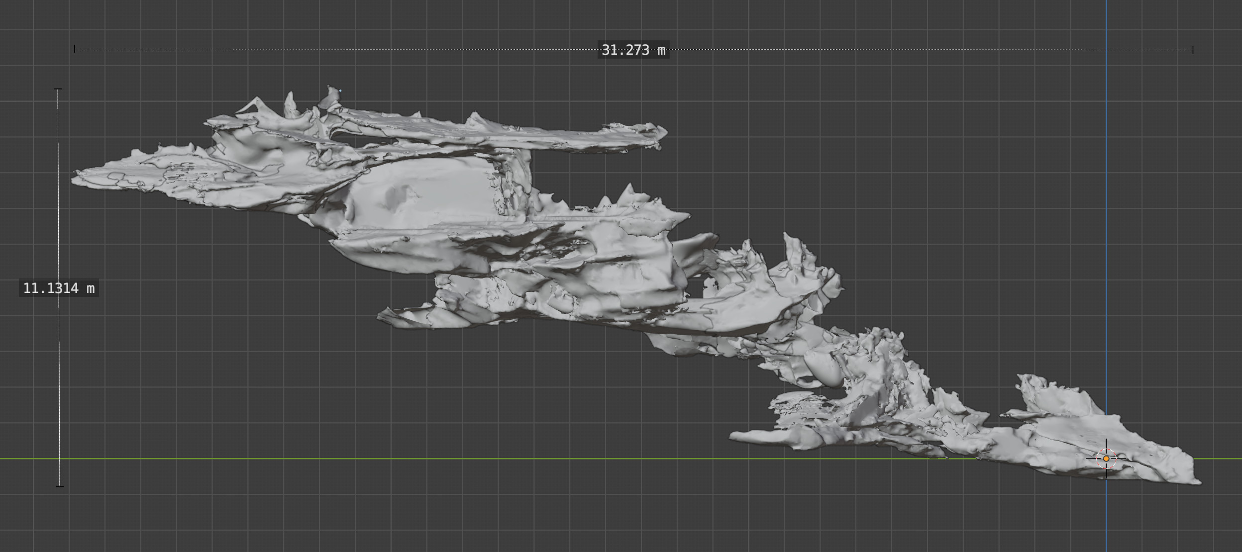
The picture above is a static side view of the model as if you were able to observe the cave from outside, but there’s an actual full 3D model behind, including textures so one can also peek inside and see what the tunnels look like etc.
This model is a composite of four parts, turned out to be difficult to scan all in one go. This should be useful for understanding the cave, drawing cross cuts and maps, or peeking inside. But this is still very experimental, none of the softwares were really meant for this, it is difficult to get good texture video in very tight passages, there’s overlap from the different parts, and the model is also too large (600k pieces, lots of detail, but chokes my browser if I try to rotate it).
The overall process for creating a 3D model of a cave is as follows:
But this is still difficult. Some of the problems that I encountered:
But, the results are still tremendously interesting and illuminating. And this is a fun thing to experiment with. I’ll keep exploring if this can be made to work more fully.
The raw model for Torhola is available also, both in GLB and Blender formats. Do note that these models are being processed and fine-tuned; as noted they also have several issues. On my list of things to do next is various cross-sections (see here (alt. link) for an example from another cave).
I have also started to maintain a directory of all 3D models I have from Finnish caves. The directory can be found here. There's also a similar directory of all cave maps, here. Both models, maps, and all other information from Finnish caves is also directly integrated to the Psgeo mapping service that the Finnish Caving Association uses. The most recent version of the software (with support for 3D models) can be accessed here. For an example of how the models are maps are visible in the map, click on this.
This article has also been published at TGR. Read more urban exploration stories from theurbanexplorer.net, and other underground stories from planetcaver.net. Read the full Planetskier series at planetskier.net, or all blog articles from Blogspot or TGR. Photos and text (c) 2021 by Jari Arkko. All rights reserved. Thanks for Helene and Touko for accompanying me to the cave!
This article was originally published in the Planetskier Blogspot article series.
"Mongolia is kind of close, right? Story about an attempt to ski everywhere in the world where there's snow. And in some places where there isn't. On and off-piste skiing on all continents, skiing into craters of live volcanoes, climbing, photography, and travel." The Planetskier blog focuses on skiing, caving, climbing, biking, flying, sauna, and swimming adventures around the world. See the other Planetskier blog articles about skiing, caving, urban exploration, climbing, cycling, flying, swimming, and saunas.